
VIELSEITIGE FUNKTIONEN FÜR DICH
Die Bike Citizens Fahrrad-App begleitet dich auf jeder Fahrt und überzeugt mit vielen Funktionen, um dir das beste Radfahrerlebnis zu bieten.

OFFLINE & ONLINE
Egal wo du bist – Die Fahrrad-App kann sowohl offline als auch online genutzt werden.

ROUTENAUS-
WAHL
Gemütlich durch die Stadt oder pünktlich zum Termin – wähle deinen favorisierten Radweg.

INTUITIVE SUCHE
Die Bike Citizens Fahrrad-App findet jede Adresse für dich. Überall auf der Welt.

HÖHENPROFIL
Ob herausfordernde Steigungen oder rasante Abfahrten – nichts kann dich mehr überraschen!
VON A NACH ÜBERALL
Unser Algorithmus ist so konzipiert, dass er dir den Radweg vorschlägt, der am besten zu dir passt. Egal, ob du eher ein gemütlicher Radfahrer oder ein Geschwindigkeitsjunkie bist, für alle Fahrradfahrertypen ist gesorgt!


MULTI-STOP ROUTING
Von A nach B mit coolen Zwischenstopps: Multi-Stop-Routing gibt dir mehr Flexibilität bei der Planung deiner Fahrradstrecken.

PAUSEN-FUNKTION
Ein kurzer Zwischenstopp, um deine täglichen Besorgungen zu erledigen? Die Pausenfunktion machts möglich.

CYCLING-FRIENDLY
Unser Routing ist fürs Radfahren optimiert und zeigt dir die fahrradfreundlichen Wege. So kommst du entspannt ans Ziel.
MEHR ALS EIN FAHRRAD-NAVI

PLAZA
Verpasse keine lokalen Fahrrad-News, Events oder Aktionen mehr.

COOLE KAMPAGNEN
Nimm an nationalen und internationalen Fahrrad-Aktionen teil.

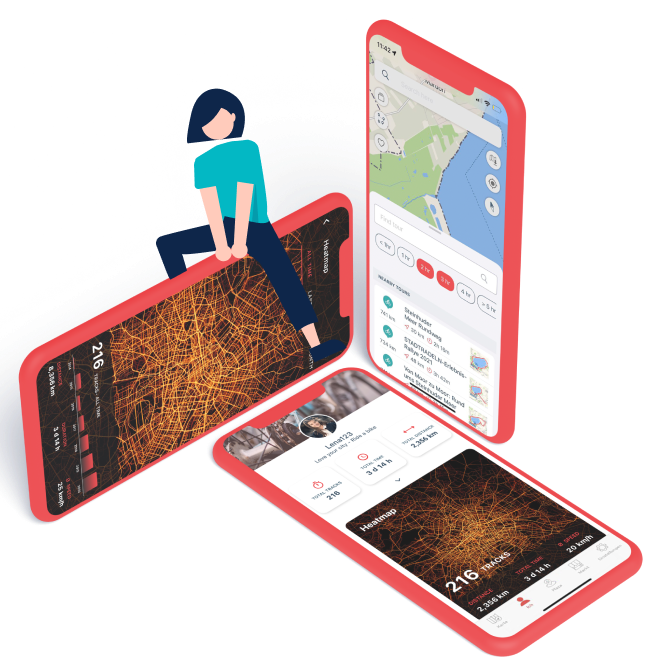
PROFIL
Sammle deine Fahrten in individuellen Statistiken und deiner persönlichen Heatmap.

E-ROUTING
Du bist mit einem E-Bike unterwegs? Wir zeigen dir wie du schnell und sicher an dein Ziel kommst.

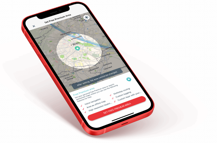
DEINE FREIE
PREMIUM AREA
Du willst den vollen Fahrrad-Spaß erleben? Installiere die Bike Citizens App und wähle deinen persönlichen Premium Bereich von sieben Kilometer Durchmesser. So lernst du alle Funktionen schnell, unkompliziert und kostenfrei kennen. Du willst alle Funktionen, immer und überall? Dann wähle deinen Abo-Plan.

VOICE-OVER NAVIGATION
Das Telefon in der Tasche und die Navigation im Ohr – wir begleiten dich auf deiner Fahrt!

OFFLINE NAVIGATION
Erstelle dir deine Kartenausschnitte nach Lust und Laune so, dass du auch offline dein Ziel erreichst.

TAGGING
Urlaub, Arbeit, Lieblingsfahrradtour – versehe deine Fahrten mit Tags und behalte den Überblick.
DEIN BIKE CITIZENS ABO
Egal ob kostenfrei oder Premium – die Fahrrad-Navi-App
hält, was sie verspricht und bringt dich in jedem Fall an dein Ziel.
Du
willst mehr als das, dann wähle deinen Abo-Plan und freue dich auf
die monatlichen Updates.


GRATIS
€ 0,00
- Tracking
- On-screen Navigation
-
Bonus für registrierte Nutzer:
- Kostenloser Premium-Bereich:
Kostenlose Premium-Funktionen
(Gebiet mit 7 km Durchmesser)
PREMIUM
€ 3 ,50
/ Monat- Tracking
- On-screen Navigation
- Sprach-Navigation
- Multi-stop Routing
- Individuelle offline Karten
- Persönliche Tags
- Profil & Statistiken
- Individuelle Heatmap
PREMIUM
€ 28 ,00
/ Jährlich- Tracking
- On-screen Navigation
- Sprach-Navigation
- Multi-stop Routing
- Individuelle offline Karten
- Persönliche Tags
- Profil & Statistiken
- Individuelle Heatmap
-
-33 % günstiger
UND NICHT VERGESSEN, DER FINN MUSS MIT!
Was macht noch mehr Spaß als mit der Bike Citizens App durch die Stadt mit dem Fahrrad zu fahren? Richtig, mit der Bike Citizens App UND der Smartphone-Halterung Finn die Gegend erkunden. Universal, stark und leicht zu montieren!


MATERIAL
Aus hochwertigem Silikon,
bei - 20 Grad getestet.

DESIGN
Ein schlankes und sportliches Design,
perfekt für jede Fahrt.

GEWICHT
Leicht wie eine Feder und passt in jede Hosentasche.

HAST DU GEWUSST?

MEHR UND BESSERE
INFRASTRUKTUR FÜRS FAHRRAD
Gemeinsam Städte lebenswert und den Radverkehr planbar machen: Werde Teil der Bike Citizens Community und leiste gemeinsam mit uns einen Beitrag, um die Art und Weise, wie wir in Städten leben, zu verbessern. Wie? Deine getrackten Radfahrten werden anonymisiert und aggregiert in unserem Datenanalyse-Tool dargestellt und können deine Stadt oder Region bei Netz- und Infrastrukturplanung unterstützen.

OPEN STREET MAP
Das Kartenmaterial der Bike Citizens Fahrrad-App basiert auf der OpenStreetMap, einer frei nutzbaren Geodatenbank. Durch die ständige Weiterentwicklung von Bike Citizens sind wir nicht nur Nutzer, sondern auch gleichzeitig Beitragende an der OpenStreetMap. Ein Radweg ist nicht richtig eingetragen? Füge ihn selbst auf der OpenStreetMap hinzu.

Melde dich jetzt für unseren Newsletter an.
Nur etwa einmal im Monat, versprochen.

BIKE CITIZENS APP
Das sagen User über unsere mehrfach ausgezeichnete Fahrrad-App.
Super App für Radfahrer, übersichtliche Funktionalität, perfekte Kartendarstellung, sehr gute Zeitpunkte für die Ansagen bei der Navigation, sehr gut verständlich und äußerst gute Routen-Wahl.
Beste Rad-Navigation, die ich kenne. Super finde ich die Aufzeichnung meiner Routen und die dadurch entstehende Heatmap. Empfehlenswert!
Meine Erfahrung mit der App waren größtenteils positiv. Ich hatte den Eindruck, dass sich hier jemand Gedanken gemacht hat, wie man Radfahrer sicher durch die Stadt bringt.